Property Fraud Alert
PROPERTY FRAUD ALERT SIGN UP NOW!
According to the FBI Property and Mortgage Fraud is the fastest growing white collar crime. It can be as simple as someone recording a document in the Buffalo County Register of Deeds office land records that fraudulently makes it appear as if they now own your property.
To address these concerns, your Register of Deeds Office have a FREE service that will NOTIFY you when or if a document is recorded that matches your personal criteria.
As, your Register of Deeds, I urge you to monitor the Public Real Estate records filed using your name.
SIGN UP NOW!!! It’s simple. Just enter your personal or business name and your contact information and you will be notified by the method selected as any documents are recorded in the future.
Buffalo County, Register of Deeds --- Kellie John
Register of Deeds Records Online Information
Search County Land Records 24 Hours a Day!
Laredo
Designed for users who consistently search in a single county
Fidlar Software has designed Laredo, a remote access product, with your objectives in mind. Laredo’s innovative technology and 24-hour access to the county’s land records allows you to obtain information faster and more efficiently.
Benefits
- Same user interface that is used on the courthouse workstation
- Real time, 24/7 access
- Customizable results screens
- Subscription based
Cost Breakdown:
Per-minute Plan Charges
| Minutes |
Price/Month |
Overage Charge/Minute |
| 0-250 |
$75 |
$0.25 |
| 251-500 |
$125 |
$0.20 |
| 501-1000 |
$200 |
$0.15 |
| 1001-2000 |
$300 |
$0.10 |
| Unlimited |
$450 |
|
**Per minute charge for each minute over the signed-up plan
To Sign Up:
To become a Laredo Subscriber please contact the Buffalo County Register of Deeds Office @ 308-236-1239.
To Search:
Once you have signed up, and have been issued a username and password, go to the Fidlar website select Nebraska as the state, then Buffalo as the county, and click download.
Tapestry
Designed for the occasional users or those who want the freedom to search in all Fidlar counties
All you need is a web browser for 24/7 access to county land records. From the Tapestry web site, users can access information from ALL participating counties. Tapestry allows for both pay-as-you-go access, and an open account payment plan.
Benefits
- 24/7 Remote Internet access
- Secure browser based access
- Search via many data parameters (grantor/grantee, date range, document number, legal description, etc.)
Tapestry Cost Breakdown
- Index/Image Search - $8.75 per search
- Grantor/Grantee
- Beginning/Ending Date
- Consideration amount
- Legal description - Subdivision, parcel ID, Metes & Bounds
- Document search types
- Print copies - $1.00 per page
- Viewing images is included in the per search fee
Flexible Payment Options:
- Pay-as-you-go with a credit card - Visa & MasterCard accepted
- Open Account Payment Plan - $25 minimum per month
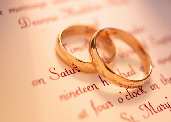
Marriage License
Requirements for a marriage license issued by Buffalo County:
| 1. |
Applicants must be at least 17 years of age to be married in the state of Nebraska. Parental consent is required for applicants who are 17 or 18 years of age. The parental consent forms are available at the County Clerk's office.
|
| 2. |
Both applicants must appear together at the County Clerk's office between the hours of 8 a.m. and 4:30 p.m. on weekdays.
|
| 3. |
The fee for a marriage license is $25.00, CASH ONLY. (See our ATM locations in the courthouse.) |
| 4. |
Must present photo identification. A valid driver's license from any U.S. state, Nebraska ID card, U.S. Passport, U.S. Military card, or a Foreign passport are acceptable forms of photo identification. All documents will be in English or translated by a certified court translator. Proof of citizenship or immigration status is neither relevant or required.
|
| 5. |
Need to know birthplace for both applicants. |
| 6. |
Need to know full names and birthplaces of parents.
|
| 7. |
If a social security number has been issued to the applicants, we will need that information. The issuance of a social security number to either applicant is not required to obtain a Marriage License.
|
| 8. |
If there were any previous marriages we will need to know how they ended (divorce, annulment or death) and the date the divorce was final or the date of death. If there is a previous divorce, a new license will not be issued and you cannot remarry until at least six (6) months and one (1) day have passed from the date the Decree was signed by the judge and filed with District Court.
|
| 9. |
The Marriage License is good for one year from the date of issuance and can be used in any County in Nebraska.
|
| 10. |
All marriage licenses obtained in Nebraska are public record.
|
All marriage licenses obtained in Nebraska are public record.
For information about scheduling the Buffalo County Court Magistrate to conduct a marriage ceremony, contact Sharmin Gonzales at sharmin.gonzales@nejudicial.gov or 308-236-1229.
Certified copy of a Buffalo County marriage license
To Receive a Buffalo
County certified marriage license either stop by the clerk’s office with $9.00
cash or send a $9.00 money order and the following information:
- Name of Applicant A/Groom
- Name of Applicant B/Bride
(including maiden name)
- Date of marriage (Must be issued from Buffalo County)
Mail to:
Buffalo County Clerk
PO Box 1270
Kearney, NE 68848-1270
If you have any questions, contact us by:
Phone: (308) 236-1226
E-mail: clerk@buffalocounty.ne.gov

Changing name after
the wedding
This is a personal decision. You may choose to keep your name but if you decide to change your name legally, you should do the paperwork as soon as possible after you're married (or after your honeymoon). Many entities will require you to present a certified copy of your marriage license as proof of legal status to make your name change. Photocopies and keepsakes are not recognized by most government offices as proof of marriage. The following is a list of what may need to be updated.
- Social Security Card (require certified copy)
- Bank, credit union, and investment accounts
- Vehicle title/registration
- Driver's license (require certified copy)
- Mortgage
- Homeowner's insurance
- Life insurance
- Car insurance
- Medical and dental records
- Credit cards and files
- Deeds and property titles
- Passport
- Voter registration card
- IRS forms
- Church records
- Mail and newspaper subscriptions
- Employer/payroll
- Post office
- Your attorney (to update legal documents, will)
- Military records
- Utilities/Subscriptions
Return to top
THIS INFORMATION IS SUBJECT TO CHANGE WITHOUT FURTHER NOTICE.
Geographic Information System
Click the button below to access GIS:

Our GIS site is open to the public with three offices currently online.
On the Assessor tab you will be able to view parcels and section information. A photo and sketch of each parcel are also available. If you have any questions about information on the Assessor tab, please call 308-236-1205.
On the Planning/Zoning tab you will be able to see information on floodplains, wellhead protection areas, and county zones. If you have any questions about information on the Planning/Zoning tab, please call 308-236-1998.
GIS Data For Download
You can now download some of our GIS layers below. The data is available in shapefile format only.
Centerline Data (Updated 2015-05-06)
Services
| Assessor |
| Valuation protest information |
| Homestead
exemptions |
| Mobile
home ownership transfer |
| Charitable, religious, and educational tax exemptions |
| |
| Attorney |
| Prosecute cases |
| Collect bad checks |
| Child Support |
| Inheritance tax review |
| |
| Board of Commisioners |
| Board of Commissioners minutes |
| Board of Commissioners agendas |
| Board of Commissioners notices |
| Property tax protests |
| |
| Clerk |
| Marriage
license information |
| Military discharge information |
| Proof
of publications |
| Corporations |
| Partnerships |
| County budget |
| County vendor claims |
| County payroll information |
| School census records |
| Minutes
of the Board of Commissioners meetings |
| Waste hauler permits |
| Tobacco licenses outside city limits |
| |
| District Court |
| Issue
writs and orders |
| Collect
and dispense fees for Child Support |
| Keep
records, books and papers pertaining to court |
| Record
proceedings of court |
| Issue passports |
| |
| Election |
| Voter information |
| Voter registration |
| Absentee voting |
| Absentee ballot |
| Polling places |
| Election calendar |
| Election results |
| Poll worker information |
| |
| Floodplain |
| Issue
floodplain permits for residences or structures |
| |
| Highway |
| County road information |
| County bridge information |
| |
| Public Defender |
| Court appoints to defend someone who can not hire their own
attorney |
| |
| Register of Deeds |
| Mortgages |
| Deeds
of trust |
| Plats |
| Old land records |
|
| Sheriff |
| Enforce laws |
| Preserve
the peace |
| Provide
a safe environment |
| Answer
911 calls and dispatch appropriate authority |
| |
| Surveyor |
| Establish
boundaries |
| Locate lots, plots, parcels, tracts, or division of land |
| Division
may include distance, direction, elevation and acreage |
| Furnish legal descriptions to be used in the platting or subdividing
of land |
| Determine
the amount of acreage in land surveyed |
| Establish
and reestablish corners |
| Topographical
plat |
| |
| Treasurer |
| Tax payment information |
| Drivers license |
| CDL's |
| Learner's permits |
| ID
cards |
| Motor vehicle licenses and registrations |
| Boat registrations |
| Specialty license plate applications |
| |
| Veteran Services |
| Veteran's benefits |
| Military discharge records |
| |
| Weed Control |
| Plant identification |
| Weed control issues |
| Enforcement
of state weed laws |
| |
| Zoning |
|
Approve and issue zoning permits
|
|
Receive applications for zoning variance permits
|
|
Receive applications for change of zoning permits
|
|
Receive applications for special use permits
|
|
Conduct inspections of setbacks and
uses of land
|
Planning & Zoning Commission
Office Hours: Monday - Friday: 8:00 a.m. - 5:00 p.m.
2025 Planning and Zoning Commission Deadlines and Meeting Times
2025 Board of Commissioners Deadlines & Meeting Times
Objectives
• Review and recommend, to the County Board, the enactment and amendment of Buffalo County’s Zoning Map, Zoning Code, and Subdivision Code. Also this Commission conducts population, housing, and growth studies of Buffalo County and its rural areas. From this study, the Commission formulates Buffalo County’s Comprehesive Plan. That Plan provides to the Commission and this county a direction as to future growth and development for Buffalo County’s unincorporated and rural areas, including any Zoning Map or Code Amendments that be needed to pursue the goals of the Comprehensive Plan.
• Analyze and submit recommendations of approval or disapproval, of any applications regarding Subdivisions of any Development-Type Operations and Special Uses as identified in the County’s Zoning Code and Subdivision Code to the Buffalo County Board of Commissioners.
• Public meetings are held on the third Thursday of each month, at 7:00 p.m., at the Buffalo County Courthouse, unless otherwise posted.
|
Note: Government Offices can only accept written documents for filing into official government records unless specific statutory language authorizes filings done by other than written medium.
|
|
Fees:
| Filing |
Fee |
| *Zoning permits |
$100.00 ****** |
| *Conditional/Special Use permits |
$50.00 plus estimated cost of publication |
| *Rezoning |
75.00 plus estimated cost of publication posted at time of filing |
| *Amendments to Comprehensive Plan, Zoning Regulations, Subdivision Regulations and Zoning map |
$75.00 in each instance plus estimated cost of publication posted at time of filing |
| *Variances submitted to Board of Zoning Adjustment |
$100.00 plus estimated cost of publication posted at time of filing |
**Administrative Subdivision Fees for Buffalo County:
| Filing |
Fee |
| Filing with Zoning Administrator |
$300.00 plus estimated cost of publication at time of filing ****** |
Modifications after filing
Plus filing fees set by Register of Deeds |
$150.00 plus estimated cost of publication at time of filing ******
|
| Plus per lot fee of |
$50.00 ****** |
**Non-Administrative Subdivision Fees for Buffalo County:
| Filing |
Fee |
| Preliminary Plat |
$200.00 *** ****** |
| Final Plat (applied each portion if staged) |
$100.00 *** ****** |
| Plus per lot fee of |
$50.00 |
**Other Processes or Events Fees for Buffalo County:
| Filing |
Fee |
| Minor Subdivision Changes |
$100.00 plus estimated cost of publication at time of filing ****** |
| Vacation of Plat or part thereof |
$250.00 plus estimated cost of publication at time of filing
$125.00 plus estimated cost of publication at time of filing for administrative subdivisions ***** |
| Variance |
$100.00 plus estimated cost of publication at time of filing ****** |
| Fee if public hearing postponed |
$50.00 |
| Fee for process if not otherwise stated |
$50.00 |
****Conservation or Preservation Easements Fees for Buffalo County:
| Fee |
| $125.00 or $2.00 per acre, whichever is greater |
Plus filing fees set by Register of Deeds unless Code states otherwise
*Passed at Board of Supervisors meeting on May 28, 2002
**Passed at Board of Supervisors meeting on February 24, 2009
***Passed at Board of Supervisors meeting on September 14, 2010
****Passed at Board of Supervisors meeting on November 23, 2010
*****Passed at Board of Supervisors meeting on June 11, 2013 retroactive to May 14, 2013
******Passed at County Commissioners meeting on April 25, 2017 effective July 1, 2017
Surveyor
County surveyor powers and duties:
(1) It shall be the duty of the county surveyor to make or cause to be made all surveys within his or her county that the county surveyor may be called upon to make and record the same.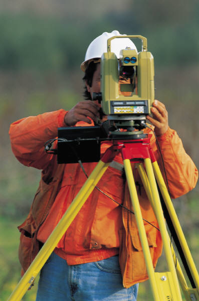
(2) The county surveyor shall prepare and file the required annual inventory statement of county personal property in his or her custody possession as provided in sections 23-346 to 23-350.
Trespass; exemption from liability. The county surveyor in the performance of his official duties, shall not be liable to prosecution for trespass.
Original corners; perpetuation. It shall be the duty of the county surveyor in surveys made by him or her to perpetuate all original corners not at the time well marked, and all corners or angles that he or she may establish or reestablish, in a permanent manner by setting monuments containing ferromagnetic material, according to the instructions of the State Surveyor.
Corners; establishment and restoration; rules governing. The boundaries of the public lands established by the duly appointed government surveyors, when approved by the Surveyor General and accepted by the government, are unchangeable, and the corners established thereon by them shall be held and considered as the true corners which they were intended to represent, and the restoration of lines and corners of said surveys and the division of sections into their legal subdivisions shall be in accordance with the laws of the United States, the circular of instructions of the United States Department of the Interior, Bureau of Land Management, on the restoration of lost and obliterated section corners and quarter corners, and the circular of instructions to the county surveyors by the State Surveyor under authority of the Board of Educational Lands and Funds. The county surveyor is hereby authorized to restore lost and obliterated corners of original surveys and to establish the sub divisional corners of sections in accordance with the provisions of the section and section 23-1907. Any registered land surveyor registered under the provisions of sections 81-8,108 to 81-8,127 is hereby authorized to establish any corner not monumented in the original government surveys in accordance with the provisions of this section 23-1907. Subdivision shall be executed according to the plan indicated by the original field notes and plats of surveys and governed by the original and legally restored corners. The survey of the sub divisional lines of sections in violation of this section shall be absolutely void.
Surveys; records; contents; available to public. The county surveyor shall record all surveys, for permanent purposes, made by him or her, as required by sections 81-8,121 to 81-8,122.02. Such record shall set forth the names of the persons making the application for the survey, for whom the work was done, and a statement showing it to be an official county survey or resurvey. The official records, other plats, and field notes of the county surveyor's office shall be deemed and considered public records. Any agent or authority of the United States, the State Surveyor or any deputy state surveyor of Nebraska, or any surveyor registered pursuant to sections 81-8,108 to 81-8,127, shall at all times, within reasonable office or business hours, have free access to the surveys, field notes, maps, charts, records, and other papers as provided for in sections 23-1901 to 23-1913. In all counties, where no regular office is maintained in the county courthouse for the county surveyor of that county, the county clerk shall be custodian of the official record of surveys and all other permanent records pertaining to the office of county surveyor.
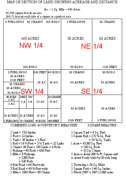
Land surveying. Land surveying shall mean the establishment or reestablishment of corners and the boundaries and the location of lots, parcels, tracts, or divisions of land, which may include distance, direction, elevation, and acreage, and the correct determination and description of lots, parcels, tracts, or divisions of land for, but not limited to, any of the following purposes:
- To furnish a legal description of any tract of land to be used in the preparation of deeds of conveyance when the description is not the same as the one in the deed of conveyance to the current owner or when bearings, distances, or measurements are needed to properly describe the tract being conveyed
- To furnish a legal description of any land surveyed to be used in the platting or subdividing of the land
- To determine the amount of acreage contained in any land surveyed
- To furnish a topographic plat of a lot, parcel, tract, or division of land and locating natural and artificial features in the air, on the surface or subsurface of the earth, and on the beds or surface of bodies of water for the purpose of establishing the facts of size, area, shape, topography, and orientation of improved or unimproved real property and appurtenances to the real property.
Office Hours: Monday - Friday 8:00am-5:00pm
Register of Deeds
Kellie John
Register of Deeds
Office Hours: Monday - Friday 8:00 a.m. to 5:00 p.m.
Location Buffalo County Courthouse - 1512 Central Ave
The Register of Deeds Office is responsible for maintaining and securing the permanent land records of the County. The Register of Deeds is a separate office in counties that have more than 20,000 inhabitants.
The duties include the preservation and recording of the land records. Every document must be proofed, indexed, and all transactions meeting the statutory requirements. This office routinely deals with complex legal descriptions and requires accuracy and detail. Legal documents, such as, but not limited to Deeds, Mortgages, Deed of Trusts, Easements, Subdivision Plats, and any and all documents that affect a specific tract of land in the county. In addition to the Public, this office is utilized by Real Estate Companies, Title and Abstract Companies, Appraisers, Attorneys, and Genealogist.
The Register of Deeds records are available on the Free Public Access computers. All copies and Buffalo County plat books are available to purchase in the office.
For information on Laredo and Tapestry, click on Deeds Records Online, to the left.
Laredo - If you are looking for online access and want a subscription.
Tapestry - You need a copy immediately or are a frequent user, pay with credit card. Get started with Tapestry.
Subdivision List by Subdivision Name
History:
The first courthouse of Buffalo County erected at Gibbon in 1873. History tells us that the Gibbon Courthouse records were placed in a wagon, brought to Kearney at night hidden in the “Chandler Building’ where the Telephone Company is today. (More Buffalo County history)
The first deed recorded in Buffalo County was a 40-acre tract of land in Section 13, Township 9, North, Range 13 West. The date of the recording was February 12, 1870.
Schedule of Recording Fees
| Buffalo County Register of Deeds
|
Term
|
| T.J. Scott
|
January 1894 to January 1898
|
|
David Mathieson
|
January 1898 to January 1902
|
| T. G. Spencer
|
January 1902 to January 1906
|
| V. B. Wheelock
|
January 1906 to January 1915
|
| T. J. Scott
|
January 1915 to January 1927 |
| Lydia Finke
|
January 1927 to January 1935 |
| Mabel Rice
|
January 1935 to January 1959
|
| Sam Spahr
|
January 1959 to January 1975 |
| Margaret Swanson
|
January 1975 to January 1999
|
| Kellie John
|
January 1999 to Current
|
Alphabetical Index of Buffalo County Land Patents Compiled by the Buffalo County Register of Deeds
|